Imbak
Canyon- Where is it?

Malaysia Map
Imbak Canyon Conservation
Area is located almost right in the heart of Sabah,
just north of the famous Maliau Basin. It is in the
Yayasan Sabah Forest Management Area, approximately
80 kilometers south of Telupid.
Geographical
Features
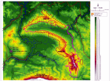
The
area inside Imbak Canyon displays a system of sub parallel
streams trending approximately N-S to the main Imbak
River, which flows from the west to the east. The orientation
and shape of the Canyon follows the main Imbak River
system. The 25 km long Canyon averages about 750 m deep
and about 3 km wide. The floor of the Canyon lies about
150 m above sea level whereas the rim of the canyon
rises to over 1500 m above sea level on the southern
ridge. A broad valley floor characterizes the Canyon
with gentle slopes on its northern and southern sides,
the slopes abruptly becoming steep near the rims of
the canyon.
Headward
erosion along the N-S trending river tributaries has
created V-shaped valleys and several waterfalls. Along
the North Tributary of Imbak River, deep gorges, up
to 50 m wide and 30 m deep, have been carved into the
recent alluvium (boulders and gravel) and bedrock (sandstone
and mudstones).